Saturday, November 30, 2019

Selby Christmas Market 2019

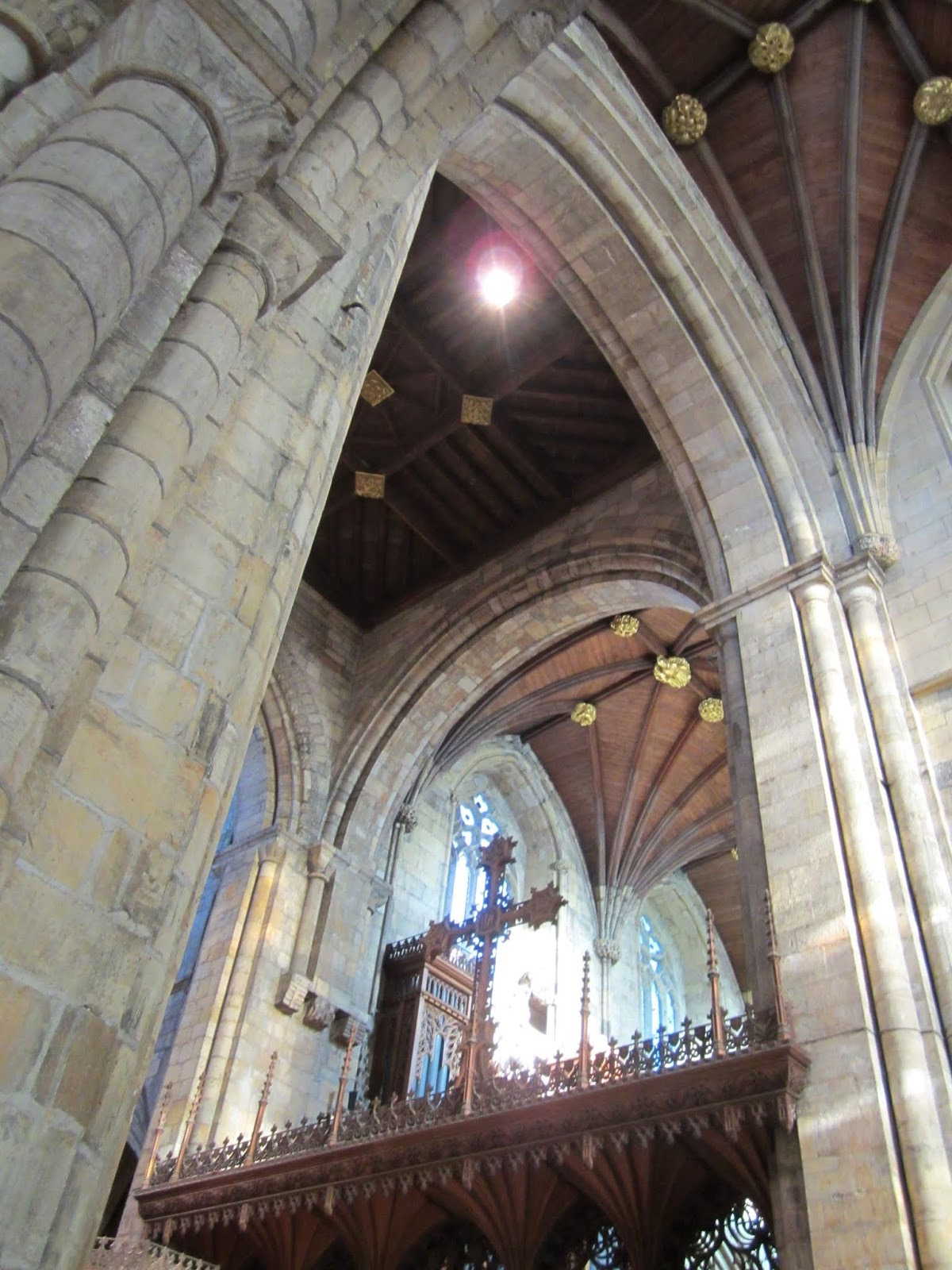
I went to Selby Christmas Market on the bus with my brother and my friend Justin today. We all decided to go our separate ways in Selby. I went straight to the Christmas Market, most of the stalls were set up inside the abbey as usual; this meant that I concentrated on photographing the ceiling and the vaulting, pointing my camera upwards and frequently holding it above my head - not always being able to see what was being captured by the viewfinder.


This blue plaque doesn't refer to the abbey.


A couple of hours later I bumped into Justin for the second time and he told me that he needed to go to the toilet. There are public toilets in the abbey and so we went inside. I took a few more photographs but also took the opportunity to have Justin take a few shots of me among the magnificent surroundings. So that I'd be looking my best I removed my rucksack and put it on the floor...but I forgot to pick it up.

It was ten minutes later, after leaving the building, that I realised that I'd left my rucksack behind and so we immediately returned to the abbey. Fortunately someone had handed it in.

As I was waiting for it to be returned to me we were having a chat with the verger and the fact that the status of the abbey is merely that of a parish church was brought up and that although it relies totally on volunteers yet is open every day of the year.

Justin had to chip in with a question - he asked if the abbey opens even on Christmas Day...


Friday, November 29, 2019

Stairfoot, Monk Bretton Priory, Notton, and Newmillerdam

Another late start this morning and so I didn't arrive at the start of the walk at Stairfoot, a couple of miles east of Barnsley, until 10:20. I headed north along the busy road towards Cundy Cross and would then continue along the Dearne Way long distance footpath.

But first I did a short detour to Monk Bretton Priory.


After a few minutes I reached the Dearne Valley Country Park and stayed within in for a couple of miles before picking up the route of an old railway line.


In the deepest part of the railway cutting it was still flooded in places and my progress was slow; fallen leaves were making it difficult to judge the depth of water and on a couple of occasions I had to climb up onto the embankment and then edge my way forward.

A short section of this abandoned railway line isn't shown as a definite public footpath on the Ordnance Survey map yet it was obviously used by locals...and so I used it as well. I soon found out why the official footpath has been diverted though; it seems that there's an area that is almost permanently flooded, or at least boggy - this wasn't a problem though because an alternative route sticking to higher ground had been established...well established over the years.

I  had to walk along a short stretch of country road and briefly entered the western outskirts of Notton before re-joining the footpath.

There was some quite nice countryside on the approach to Newmillerdam Country Park.


I then entered some woodland and was soon walking along the lakeside path; the photographs feature the boathouse..


It was more convenient for me to catch a northbound bus to Wakefield and then the train back to Doncaster than it was to catch a southbound bus to Barnsley and then another bus back home; I even let a southbound  bus go.

Today has been a perfect day for walking and taking photographs, it's just a pity that I didn't have enough time to get to the Peak District.


Sunday, November 24, 2019

Castleton, Pindale, and Brough

It's not been a good day for photography; it stayed quite misty all the time. Some of the photographs I took though looked wonderful on the camera's small screen but I wasn't satisfied with the quality of the images when viewing them at home on my laptop..so they haven't appeared on the blog..

I travelled to Castleton and initially spent a bit of time photographing the Christmas decorations and the shop window displays - I was having problems with reflections and focusing with my subject matter being behind glass, and the interior of the shop spoiling the composition of the shot. One thing I think I do need to mention about the Christmas displays at Castleon is that some of the Christmas trees block the pavements, and that's not good because it forces people to walk in the road.


Once I left Castleton the photos are a lot less colourful because of the murky weather. On the subject of colour; quite a few of the sheep that I saw had been sprayed with, or dipped in, something light brown.


I left the village and headed out to the west, towards the abandoned road at the foot of Mam Tor.


Even though it was misty and miserable it was actually quite warm and a lot of people were out walking today - some of them only wearing tee-shirts.

I didn't climb Mam Tor, instead I went south, and then east, along tracks and a short section of road until I reached Pindale.


I then walked down the road towards Hope, but although there are four cafes/tearooms at Hope I didn't go there today; instead I took the footpath that heads parallel to the road all the way to Brough.

I decided to end my walk at Brough because of the timings of the buses going back to Sheffield. It was only fifteen minutes until the next one was due, not enough time to be able to walk along the footpath to the next village...and I didn't fancy walking down the road and seeing how far I could get.


I spent the time at the bus stop chatting with a local man from Bradwell, a Sheffield United fan who was travelling into the city, but not to watch the big match this afternoon, versus Manchester United.

UPDATE:

The sheep’s backsides are to do with ‘tupping’ I.e being mated with the ram. He wears a big dye pack on his chest, so the farmer can see which ones have been mated.

Thanks to Sue commenting on the 'Walking Around The Peak District' Facebook page.


Monday, November 18, 2019

Malin Bridge, Load Brook, Ughill, Low Bradfield, High Bradfield, Foldrings, and Oughtibridge

Public transport ran on schedule for me today; three trams, two trains, and a bus. After arriving at Sheffield this morning I caught the tram to Malin Bridge and then headed straight down into the Rivelin Valley Nature and Heritage Trail.


I nearly bumped into a jogger because neither of us knew which side of the path to move to; it's generally a lot simpler when I encounter mountainbikers - quite often they'll yell out 'To Your Left' or 'To Your Right' and pass on that side.

I didn't go right to the end of the trail, instead I climbed out of the valley just before the parking area at Tofts and walked up onto the high fields.

I headed west towards Bradfield, passing through the hamlets of Load Brook and Ughill.; I stopped to photograph this piece of agricultural machinery - I was intrigued by the scrubbing brushes.


At a junction of two roads on my way down to Low Bradfield I noticed some sort of monument or obelisk over to my left. There was an inscription and a date but it was well worn and indistinct. I shall do some online research later and post any information I find.


It's dangerous to walk up the road from Low Bradfield to High Bradfield; fortunately there's a lovely footpath across the fields. It's a fairly steep climb and at the top I was ready for my glass of Diet Coke or whatever it was, at the Old Horns Inn.

As usual I took some photographs of the village church.


I left High Bradfield by taking the footpath that goes off to the northeast and the next place I arrived at was Foldrings. I then walked through some woods and down the road to Oughtibridge. Many of the views in this area are spoiled by pylons and power lines - I did manage to compose these three images though...with quite a bit of cropping required for the final two.


UPDATE:
 Hoar Stones Road near to Edgefield Farm, above Bradfield. This unusual building is described, in Roger Redfern's book Portrait of Bradfield Dale, as being built over a roadside spring and was erected over the spring after a child drowned there in 1832. The Obelisk is in memory of this sorrowful event.

Thanks to Mick Walpole, replying on the Peak District Past and Present Facebook page.