Sunday, August 27, 2017

Elsecar, Tankersley, Warren, Spittal Houses, and Wentworth

A change of routine today. Normally when I go walking with Chris and Maureen, my friends from Leeds, I meet them at Fox House up on the moors and then we drive to wherever we're starting from. Annoyingly there are no early morning trains running from Doncaster to Sheffield on Sundays for the next few weeks because of scheduled engineering work so I couldn't get to Fox House until much later than our regular ten o'clock pick-up time.

So, we went on a much more local walk for me, out to Elsecar near Barnsley. I met Chris and Maureen at Warmsworth, near to the A1(M) roundabout, and it took us about twenty minutes to reach our destination - the car park at Elsecar Heritage Centre. We immediately went inside to use the toilets and have a quick look round - both the parking and admission is free. 

Chris was particularly interested in the heritage railway station and the Newcomen Beam Engine.


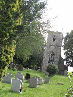
We then started our walk, headed to the west via Elsecar Park and Skier's Spring Wood, going along a short section of the TransPennine Trail before turning to the north to pass the ruins of Tankersley Old Hall - there's no public access and the ruins look to be in quite a perilous state. A few minutes later we reached our lunch stop, Tankersley Church...a lovely location.


Navigating the next section of the walk through Tankersley Park Golf Course wasn't easy - the signage was poor so we just took to walking down the fairways until we reached the club house and a path that we could then follow.


We crossed over the A61 road and walked next to the perimeter fence of an industrial estate; I noticed by the signs that we were now inside the boundary of the City of Sheffield. Next up was the village of Warren, pretty boring and unattractive, before then walking along the main road for a few yards before reaching the bridge over the motorway. 

It was a pleasant walk across the fields, past a couple of commercial stables, and through a small wood until we reached the small hamlet of Spittal Houses, and then Wentworth. We only entered the western edge of the village today...passing next to the old ruined church though.


It was about a further mile and a half, mainly downhill, back to Elsecar where we had time to pop in to the tearooms. I had a cream tea, Chris had a sausage sandwich and Maureen some green tea. 


There was a 'Gift and Grub Fair' inside one of the buildings; I bought a pork and lime pickle pie for my supper.

Saturday, August 26, 2017

Youlgreave to Matlock.

Another walk today where I travelled to Bakewell and then caught one of the local buses to the start of my walk. 

I got off the bus at Youlgreave and after having taken some photographs of the church I walked down the hill to Bradford: after a few minutes I needed to step aside to let the local hunt pass me, being careful to stay well away from the dogs and the horses...there were a lot of both.


I picked up the Limestone Way at the clapper bridge at Bradford - it was a steady climb up through pleasant countryside with nice views both in front and behind.


I needed to walk along a short stretch of road before approaching Harthill Moor Stone Circle; I didn't actually enter the circle because this would mean a bit of a detour for me, but the main path goes close enough to get a decent view of it. The last time I was here the farmer had deliberately parked a trailer inside the circle...this received a lot of criticism and possibly ended in legal action, I think.


It's only a short walk and an easy climb up to Robin Hood's Stride, an interesting rock formation. I had the time, and the energy, to climb to the highest point I could reach - it was a good place to eat my sandwiches.


For the next three and a half miles I continued to follow the Limestone Way, both the walking and the navigation was easy. The route passes close to Birchover and Winster, without actually entering the villages. At the nearest point to Winster I took a photograph of the Lead Ore House.


To the south of Brightgate I temporarily left the Limestone Way to take the shortest route down to Matlock, walking along a road for about a mile. As I passed by the footpath that leads to Jughole Wood I saw a lot of cars parked on the side of the verge; I'm assuming there must have been a large group of cavers down in the old mine that's located there.

A few hundred yards later I picked up the Limestone Way again and followed it for the rest of the way to Matlock.

I only had seven minutes to wait for my bus at Matlock, and fewer than five minutes at Bakewell for the next bus back to Sheffield.

I'm feeling really good after finishing today's walk of about seven miles...which is good because I'm going out walking again tomorrow with my friends from Leeds. The walk tomorrow won't be as hard or as far as today though. Today wasn't difficult at all for me though, it was a bit of a doddle...in truth at times it felt as though I was flying. I've really noticed this past year how much less the gravity is on planet Earth these days. Taking both vitamin D and metformin [and now weighing six and a half stones less] has worked wonders for my health.


Thursday, August 24, 2017

Don Gorge Discovery Day...and a Cruise on the River

A very pleasant surprise today, an unexpected short cruise on the River Don.

I went to Sprotbrough with Marshall, my support worker, as we usually do most weeks on a Thursday - just to eat our sandwiches and go for a short walk along the river or up into the woods. However, today we were pleasantly surprised to find out that it was the Don Gorge Discovery Day, and this year free cruises on the 'Wyre Lady' were being offered. Our timing was perfect; we arrived at 11:45, just in time for the twelve o'clock sailing to Conisbrough and back.

When we arrived back on dry land we were able to visit the stalls and exhibitions...and also go inside the lock house to have a look at the equipment.


Peak District Trig Points


I've just found a list online of all the trig points in the Peak District. I reckon I've visited eleven of them since I started writing this blog - I certainly must have visited several more when I was much younger too.

Back Tor: On the moors to the east of Derwent Reservoir - plenty of interesting rock formations up here.

Birchen Edge: Next to Nelson's Monument and The Three Ships rocks. The Robin Hood pub is nearby.

Brown Knoll: I stopped here with a couple of friends to eat our sandwiches as we were on our way to Kinder Scout.

Calton Pastures: I've rested here several times, or to eat my sandwiches. Some lovely views of the Chatsworth estate.

High Neb: One of the two trig points on Stanage Edge.

Mam Tor: It's a popular climb up here from Castleton - I've never had the summit to myself.

Oaker Hill: Probably the lowest of the trig points, but it's a lovely view of the Derwent Valley from here.

Stanage Edge: The second of the Stanage Edge trig points, further south than High Neb. I think this is the one that's easier to clamber over the rocks to reach.

Stanedge Pole: I didn't even realise that this was classed as a trig point. The Pole has recently been replaced and information plaques added to the base.

Sir William Hill: Looking at the map I must have walked by this location several times but I don't recall seeing the trig point.

White Edge: Located on Big Moor; this trig point must have recently been re-painted by someone since it's now a very bright white colour.

Win Hill: Great views of Ladybower Reservoir from up here. I've never had the confidence to actually climb up to the trig point which is perched on some precariously balanced rocks. Whenever I've been here though I've always seen people standing right next to it, or even on top of it, posing for photographs.


Sunday, August 20, 2017

South Elmsall, Skelbrooke, Burghwallis, and Sutton

For the next few weeks there will be no early morning trains running to Sheffield on Sundays so I made alternative arrangements today -  another local walk, this time travelling on the other line on which I can use my travel pass, the Leeds line.

I got off the train at South Elmsall and walked up the hill towards the church, which isn't very old but seems to have its charm. I managed to get a decent, if boring, shot from across the road.


I struggled to locate the footpath at the far end of the housing estate and ended up walking across a field of stubble. After about a mile I reached the main Wakefield road, which I crossed as the path continued to Skelbrooke. 

The church at Skelbrooke is attractive, and dates mainly from the mediaeval period.


As I was walking at the edge of a field next to the church I saw a couple of metal detectorists busy at work, the first I've ever seen on a walk.

My quickest way to the next village, Burghwallis was by taking a footpath that led straight to the Great North Road; I would also be able to see Robin Hood's Well by going this way. I was hoping there might be footbridge or tunnel...but there wasn't. I was faced with the prospect of having to cross four lanes of busy traffic: after a few minutes I managed to get across the two lanes of traffic on the northbound carriageway but there was no way I would manage the southbound carriageway, which was far busier. So I took some photos from my position of safety standing on the small paved area on the central reservation and then spun round and waited for my opportunity to re-cross the northbound lanes...I needed to wait for another three minutes until a lorry driver flashed me with his headlights.


So I re-traced my footsteps back to Skelbrooke and then walked through the village and took the footpath towards the roundabout at Barnsdale Bar, where a road crosses over the busy trunk road. I took more pictures of the village. I popped in to the roadside cafe at Barnsdale Bar for a mug of tea and to check my new route ahead on the map.


This enforced change of plan added about two, or maybe even three miles, to my route. I first took the Campsall  road, walking past the entrance to vineyard [I didn't know Doncaster had one] and then turned right down the road which leads back to the dual carriageway. Somewhere in this area I saw several more men using metal detectors in a field.


The path across the fields to Burghwallis was trouble-free and easygoing underfoot.

There's another pretty, old church at Burghwallis.


The next path, to Sutton, was very overgrown in places, so I'm glad I was wearing my full hiking gear. When I reached the village it was forty minutes until the next bus back to Doncaster was due and so I popped over the road to the Anne Arms for a glass of Diet Pepsi which I enjoyed in the large beer garden.