Thursday, December 31, 2015

From the Archives: Barnburgh

Barnburgh, about five miles west of Doncaster is situated in an area of nice countryside but it is best known for the 'Cat and Man' legend which goes back to the fifteenth century and features Sir Percival Cresacre, who lived in Barnburgh Hall at the time. He was riding home after a night out in Doncaster and was attacked by a wildcat or lynx and thrown off his horse. A fight then occurred between Percy and the animal as he struggled down Ludwell Hill towards the village. He managed to reach the porch of the church but before he could open the heavy wooden doors he died; the cat died from its injuries a few seconds later at the same spot, where the stonework is supposedly stained red with blood that cannot be washed away...it's just part of the natural coloration of the local limestone though.


The photograph I've selected features what I know as 'The Lightning Tree' just to the west of an area called 'Barnburgh Cliff.' I was there only a few weeks ago and although I wasn't specifically looking out for it, I didn't see the lightning tree...so maybe it's no longer there.

Wednesday, December 30, 2015

Pedometer


I've just bought a pedometer in the New Year Sales. It only cost £7.99 and it's full function, featuring number of steps taken, distance walked, and calories. I'll be wearing it all the time, not just on my walks...if I remember. I haven't a clue how many steps I'll clock up in a month; my friend in Leeds who works in a warehouse did 500,000 steps for the first time this month.

Saturday, December 26, 2015

From the Archives; Beeley

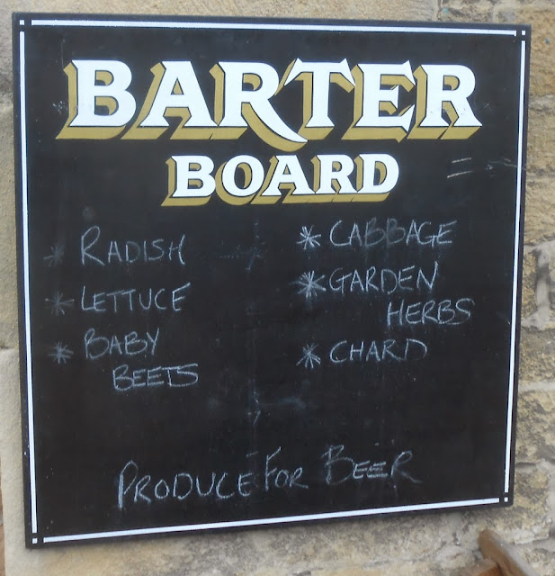
Beeley, one of the Chatsworth Estate villages is somewhere I tend to walk through rather than start or end a walk there. I did once call in the local pub, The Devonshire Arms, for a glass of Diet Coke or Pepsi and took this photograph of the barter board.


Sunday, December 20, 2015

Not As Planned: Conisbrough and Cadeby

Well...today didn't turn out as planned. I was sitting on the train on platform 5 at Doncaster Station waiting for the 08:04 service to Sheffield to set off when the guard announced that due to over-running engineering work there would be nothing departing until at least nine o'clock. So, a quick walk over to the bus station was required to see what my options were. The X78 bus was due, so I caught it to Conisbrough.

My day had been ruined, but at least I'll probably qualify for compensation from Northern Rail; a voucher for one day's free travel on their entire network.

When I got on the bus I broke the ticket machine...again. As I struggled to place my pass in front of the scanner my knuckle caught the lid of the machine, pushing it open and knocking the roll of paper into the air. Fortunately the driver was easily able to make repairs...at least a temporary fix anyhow.

Every bus operator here has a different type of ticket machine, with a different type of scanner. With some machines you need to press your pass at the front of the machine, but for others you just place it on top. I much prefer the latter. As usual, this morning the driver was sitting behind a transparent perspex security shield with a hole low down for people to pass their hand through. This is what causes a problem for me, for someone as tall as me with poor co-ordination and no proprioceptive sense. The hole is so low that I struggle to correctly position, twist, reach, and orientate my hand; I really don't have that much control. If there's no-one standing behind me I can get on the bus stooping like an old man so that I can more easily line up my hand and reach for the scanner. [I once forgot that there were people behind me and took a step backwards in order to be able to bend down a bit...with the expected results.] Oh, how much simpler things were when all I needed to do was show my pass to the driver and state my destination.

So, today's walk began, and ended, at Conisbrough. I took advantage of the early hour; the sun had just risen and so I was able to get some good, well lit photographs of both the church and castle. I observed something interesting at the main castle gates, a very athletic young man dressed all in black walked up to the gates and in one deft, militaristic movement got down on one knee, crossed himself, and then slapped each shoulder, much in the manner that I've seen mediaeval knights do in films when pledging allegiance to a king.


I then walked up on to the Crags and also along some riverside meadows where I was able to view Conisbrough Viaduct from some different angles.


From where this photograph was taken it's quite a climb up to the top of the crags. I then walked along the road to Cadeby and took some photographs of the church, or chapel - I'm not sure what the difference is.


By lunchtime it was starting to cloud over and becoming rather chilly so I decided to head off home. As I was walking past the railway station at Conisbrough I noticed that a train was due in two minutes, twenty five minutes late, so I decided to catch it back to Doncaster - it only takes a few minutes. Northern Rail's problems this morning had worked to my advantage this time.

Sunday, December 13, 2015

The Lanes And Tracks Of Hathersage

To the north of Hathersage there are a lot of lanes and tracks, I've walked up and down some of them, but there are still sections I haven't explored yet...and of course, they're all linked together by a dense network of footpaths.

I started the day with an apology.


The first lane I walked along, but only for a few yards before I took the footpath that leads towards the church, was Baulk Lane. I've not taken this path before and it was interesting to see views of Hathersage from different angles as I climbed up the side of the field - it was a well-maintained gravel path though, fenced off from the field.

'Little John' is supposedly buried at Hathersage church; I took several photographs of his grave but none of them really showed how large it is; I've settled for this shot of the church itself instead.


After leaving the churchyard I took one of the footpaths that eventually leads to North Lees Hall, crossing a road that I think is called 'Birley Lane.'


Just beyond North Lees Hall I took the path which leads to the left, in the direction of Green's House. When I reached Hood Brook I had to make a decision; the brook is usually only a trickle here and it is easy to just step over it, or ford it...not today though; it was an angry, raging torrent of wild water. Here's a link to a short video I filmed

The water seemed to be too deep and too  fast flowing for my liking, and since there was an alternative route that led down to a footbridge, that's the way I went.


Just after Green's House I spent a bit of time walking along the upper reaches of Coggers Lane, my third, and final,  lane of the day; there are several more though.

I then found a path that I was particularly keen to locate because it isn't marked on my map; it's only quite recently been designated as a concessionary footpath. I only found out about its existence by looking on the Streetview feature on Google Maps.

By now the weather was closing in and visibility was quite poor. I could just about make out Stanage Edge, Win Hill, and the entire length of the Great Ridge. On a warm sunny day in the spring or summer I can't imagine there are many places with better views to sit among the wildflowers listening to the cricket commentary and enjoying a steady supply of chilled drinks, chocolate, and a selection of cakes.

The path came out further down Coggers Lane; I soon took the path that took me past Thorpe Farm, which sells its own ice cream - I wasn't the least bit interested today.

I got a bit lost as I crossed Sickleholme Golf Course and in the end decided to head straight for the club house. A couple of footpaths cross the course and it's accepted practice to just plot your own route, causing as little disruption to the golfers as possible - I noticed a sign stating that the course was closed today though; I did observe that a couple of the greens were waterlogged and nearly every bunker had a large puddle in it.

The bus was a few minutes late arriving at the bus stop at Bamford Station. It lost even more time when it reached the outskirts of Sheffield. I have never seen so many people get on the bus as it travelled down Ecclesall Road. I think this is likely due to the re-organisation of bus services undertaken by the Sheffield Bus Partnership. I've been following developments online and it seems that there are now a lot fewer buses serving Ecclesall Road. Bus users in the city aren't very happy; provision in many other areas is also a lot worse; fortunately the buses that run out to the Peak District have hardly been affected. In truth, now that there's a regular service from the city centre out to Bradfield it can even be claimed that there's been a significant improvement. I used this bus service on my previous walk in the Peak District. 

Thursday, December 10, 2015

From The Archives: Baslow

Baslow, and Baslow Nether End in particular, is a popular place for me to start and end walks. It's situated at the northern entrance to Chatsworth Park and it's the obvious place to finish a walk along the tops of the dramatic Eastern Edges. It's easy to reach from Sheffield, with two buses an hour and the journey only takes 45 minutes. There are public toilets at Nether End, and in my opinion the Café on the Green serves the best Bakewell pudding in the Peak District.

The photograph I've selected was taken next to one of the old quarries just above Baslow. I love Highland cattle; they are so docile...and love to be photographed, always posing for the camera.


Sunday, December 6, 2015

Scawsby, Cusworth Hall, Sprotbrough, and Conisbrough

I had planned to end the walk at Mexborough, but I decided to cut it short at Conisbrough because my camera battery went flat; I'm a bit mad about this because when I checked this morning there was no 'low battery' indicator showing. A major part of a walk for me is taking photographs, so I lose a lot of the enjoyment if I'm not able to do this; there are a lot of interesting things to photograph walking along the river from Conisbrough to Mexborough; old railway structures and canal locks; I'll have to shoot them the next time.


I got off the bus at 'Teeside Close at Scawsby. 'Teeside' isn't close to anywhere at all though because it doesn't exist; there is no 'River Tee' anywhere in the country...the name of the street is a spelling mistake. It used to make me feel quite angry seeing something like this, knowing that I would never a mistake like this, having a keen interest in, and detailed knowledge of,  both geography and the English language. I like to think I would have made an excellent proofreader, editor, copywriter, or technical writer, but it never happened because of my Asperger's syndrome...and the lack of opportunities that I've had. I just felt sad this morning as I was taking the photograph; if you're reading my blog in the United Kingdom there's a good chance that through your taxes you're helping to pay my benefits and pay for my support package from social services; maybe you're the one who ought to be getting mad.

It's only a walk of a couple of minutes to the gatehouse at Cusworth Hall.


I approached the house along the driveway and took some photographs of both the front and the back of the house, although I'm not sure which is which.


It started raining as I was walking across the fields to Sprotbrough; although there were a few sunny intervals during the rest of the walk, it rained as often as it didn't - not quite as the weather forecast predicted.

As I was approaching 'The Square' I noticed that a group of cyclists had gone inside the wine bar, somewhere I've not patronised myself before when on a walk; but if cyclists are going in, I thought that I might as well give it a try. It's lovely inside; very unusual decor, tabletops made out of hundreds of corks from different varieties of wine from all over the world, and empty wine bottles used as lampshades on the walls...very romantic for an evening meal I should imagine. I ordered a pot of tea and a slice of very heavy and sticky chocolate cake which was delicious. I did end up having a bit of an accident though, a very loud accident involving the lid of the teapot and loose leaf tea being hurled into my face and hair.

I scurried out of  the wine bar and crossed the road to take some photographs of the church.


I then went down the hill towards the river, and as I was crossing over the bridge I noticed that the Wyre Lady was getting ready to start a Christmas party cruise up the river to Mexborough, and back.


It started raining again as I approached the fish pass, or 'fish ladder' as I tend to call it. I took a photograph of the newly installed piece of sculpture.


It took me quite a few minutes to reach somewhere suitable to shelter from the rain, a partially blocked up tunnel going beneath the railway. I ate my sandwiches here as I waited for it to stop raining. 

Within only a few minutes of it stopping raining it turned out to be quite bright and I thought I'd get some decent photographs, but when I tried to take a short piece of video of the Wyre Lady returning along the river I got a 'low battery' error message. I managed to take another three or four photographs after this point and then the camera went dead....so I decided to go for the quickest way to get to the road the comes out of Conisbrough and catch one of the frequent buses back into town.


Saturday, December 5, 2015

From The Archives: Bradwell


Bradwell is the village where my favourite ice cream company is based, interestingly the company's called Bradwell's. Their lemon curd flavoured ice cream is delicious.

The village itself isn't particularly attractive, but it is surrounded by some lovely countryside, and is easy for me to reach - so I quite often will start or finish a walk here. There are all the basic facilities in the village, toilets, shops...and of course, the ice cream parlour.

The photograph I've selected shows the start of one of the footpaths that leads up to the hills above the village; it's a steep climb in places.

Thursday, December 3, 2015

Peak District vs North York Moors

Something that I've known for a long time is that the area of the Peak District National Park and that of the North York Moors National Park is almost the same, 555 square miles, compared to 554.

This is certainly something the two areas have in common. I can't really think of anything else though; certainly the landscape, geography and culture is quite different - I suppose they both have, to a degree, a shared industrial heritage though.

The major differences: The North York Moors includes a section of coastline; more people live in, and visit, the Peak District; public transport access is much better in the Peak District; there is well-dressing and Hallamshire carolling in the Peak District...they might have similar cultural events in the North York Moors, but I don't know.

I've walked in both national parks...but obviously know the Peak District much better.

Tuesday, December 1, 2015

Some Unusual Place Names

Yesterday there was a comment posted to the blog from a lady in America remarking how much she loves the place names that I feature. This has given me an idea; write a post about place names - I've got nothing any better to do today, the weather's miserable and because of the course of antibiotics that I'm taking I'm feeling quite drowsy most of the time, and so wouldn't be out walking even if the weather was nice.

This is only a short list of the more striking or unusual place names I can remember at the moment:

Cakes of Bread: A rock formation on Derwent Edge - they really do look like cakes of bread...from every angle.

Chrome Hill: Unfortunately it's not made of chrome, or even looks anything like it. In this case 'Chrome' is derived from the Celtic word for 'crooked.' it's quite a distinctive hill though; I haven't visited it yet, it's difficult for me to reach. I saw it in the far distance when I was walking a few months ago in upper Dovedale with Chris, my friend from Leeds.

Coach and Horses: Another rock formation, also on Derwent Edge. It's supposed to look like a coach and horses from one particular angle. I've obviously not viewed the rocks from that angle yet because whenever I've seen them they look like nothing in particular at all.

Cutthroat Bridge; A popular location for me to start a walk from due to it being on a bus route. I think it got its name because of a gruesome event in the eighteenth century when a stagecoach was attacked by highwaymen. More recently, in the 1980s, a partially decapitated body was found in the boot of a car here.

Glutton: A village, or hamlet, over on the western side of the Peak District. I've never been there and know nothing about the place.

Gusset: Another village, or hamlet, over on the western side of the Peak District. I've not been there either and also know nothing about the place.

Hangman Stone: This isn't in the Peak District, it's a local spot quite near to Doncaster, I usually stop here to eat my sandwiches when I'm passing. The reason for its gruesome name isn't as obvious as you might think; local folklore says that the name refers to what happened to a sheep rustler. He'd killed the sheep and tied its legs together and than placed it on his shoulders to carry it home. When he reached the stone he sat down, still with the dead sheep hanging round his neck. He was tired and fell asleep, as he slouched the position of the sheep's carcass moved and strangled him.

High Low: Several locations in the Peak District share this name. In the Peak District a 'low' is actually a hill, so 'High Low' means 'high hill.'

Madwoman's Stones: Another rock formation, this time on Kinder Scout. I don't know how it got the name.

Penistone: The name of this small time frequently generates a smile or giggle when seen on a page or screen.

Ringing Roger: Another rock formation on Kinder Scout. I think it makes a whistling noise when it's windy.

Surprise View: This is one of the classic Peak District views, looking up the Hope Valley from above Hathersage. So named by Queen Victoria who was travelling by coach and was tired of crossing the bleak moorlands, but was surprised by the stunning view she saw when she reached here.

Monday, November 30, 2015

Recollections Of My Earlier Walking Days.

I was diagnosed with Asperger's syndrome in July 2009 and received my free travel pass a few weeks later, meaning that I'm now able to regularly go walking in the Peak District, or elsewhere. I didn't start writing this blog about my walks and days out until nearly a year later and during that earlier period I was doing pretty much what I'm doing now when it comes to walking. 

The only other time I went walking during the previous few years was when a small group of my schoolfriends, who I'd not seen for many years, was doing some quite long training walks in preparation for a challenge walk on the North York Moors; the White Rose Walk from the White Horse at Kilburn to Roseberry Topping. I can recall doing a walk in Nidderdale, based at Pateley Bridge and visiting the villages of Ramsgill, Lofthouse, and Middlesmoor. We also did a section of the Cleveland Way from Robin Hood's Bay to Whitby, and back, and a walk along the first section of the planned challenge walk in the North York 
Moors, from Kilburn to Osmotherley...obviously, with this being a linear walk we took two cars. I went along for the actual challenge walk but only did a couple of the sections; I don't like walking in the dark, or against the clock either.

Many years ago, over twenty in fact, I did complete a couple of challenge walks, the Lyke Wake Walk and the Shepherd's Round, both on the North York Moors as well. I can't remember doing any training for these at all; we were a lot younger and fitter then though.

I can't recall the exact details, but I also went to Bolton Abbey with some friends and we walked up onto the moors.

Apart from the last six years my most intense period of walking was in the years after I'd left school. There was a regular group of three or four of us who would go walking nearly every Saturday in the Peak District, taking two buses to get there from the pit village where we lived...we also took a dog with us. 

After a couple of years one of the lads got a car, a rather cramped Mini. This opened up new opportunities for us though, new areas of the Peak District...and the Yorkshire Wolds. In the Peak District I can remember walking in Dovedale and the Manifold Valley, and in the Wolds, Huggate and Millington [I think] seem to be familiar names.

I'm not sure if I'm remembering this correctly, but I'm convinced I was at Monsal Head at the time of both the Hillsborough Disaster and the Bradford City fire, and I always get a little melancholic when I'm there, associating such a beautiful place with so much death and tragedy. 

The only other period of regular walking I did was when an inexpensive rover ticket for travelling on the trains in West Yorkshire was introduced and myself and my brother would go walking on Ilkley Moor and areas of the Pennines beyond Halifax and Huddersfield.

Sunday, November 22, 2015

Sebaceous Cysts

I had hoped to go walking this weekend but I've got two large sebaceous cysts in my groin area which are quite sore when I walk, due to rubbing and chafing.

It was a lovely day yesterday in the Peak District, sunny and dry, yet the first snow of the winter had fallen overnight. The weather forecast for today is decent as well, but I'm having to stay at home. I read online that sitting for prolonged periods in a hot bath helps to accelerate the healing process, so that's what I'll be doing today.

Friday, November 20, 2015

From The Archives: Buxton

I don't use Buxton as a base for walking, the bus journey from Sheffield takes a hundred minutes and that's too long - I'm shattered when I get off, and it's already quite late in the day. It's also a limited service, only four or five journeys a day, and so if I don't time my return to Buxton right I've then got to worry about alternative ways back to Sheffield, changing buses at either Bakewell or Baslow.

So...I just go to Buxton for a day out and take some photographs. The photograph I've included isn't immediately recognisable as a location in Buxton; it's a church at the back of the Opera House.

Thursday, November 19, 2015

Chesterfield and Chatsworth Garden Centre

A day out with my support worker that didn't go exactly to plan...but still ended up being a pleasant visit to the Peak District.

I'd not had a really good look round Chesterfield for a long time and so enjoyed spending some time there, visiting the museum and going inside the church, famous for its 'crooked spire.'


After a stay of about three hours in Chesterfield we moved on to the Peak District, first calling at the Chatsworth Farm Shop at Pilsley. The car park was full, so we didn't stay and decided to drive down the road to the Tea Cottage at Edensor - yet again the car park was full [I don't have this problem to contend with when I'm on a walk]. There was room at the garden centre though where we lingered over tea and cake - large slices of Bakewell pudding.

Monday, November 16, 2015

Bradfield Area Walk

There's a new bus service from Sheffield City Centre out to Bradfield so I thought I'd catch it today; it only took thirty minutes to arrive at High Bradfield.

As soon as I got off the bus I crossed the road to take my first photograph; I'm not sure if the Tour de France actually came to Bradfield though, I thought it went further north.


I walked through the churchyard and then on past Bailey Hill.


There were quite a few different types of landscape for me to enjoy before I reached the road that leads to the gated access to the moors. This seat would have been a lovely spot to eat my sandwiches, but I'd already eaten them.


I made use of 'Duke Road' to cross the moors; it's quite easy walking conditions and doesn't really require any navigation skills. For part of the way it's a track used by four-wheel-drive vehicles to reach the grouse butts, and further on there's a paved section across the  boggy stretches. Because of the strong wind I found it  quite difficult at times though; I struggled to breathe and was coughing a lot.

I arrived at Back Tor unscathed, but decided not to climb up to reach the trig point.


After a few hundred yards I turned left, starting my return to Bradfield, taking the track that leads down to the road, then continued along a path high above Dale Dike reservoir.


I finished the walk at Low Bradfield after walking along the road for about a mile.

All of today's walk was in just the one parish, Bradfield Parish; it's a large parish, possibly the largest in England - I'm not certain though.

Sunday, November 15, 2015

From The Archives: Bakewell

Well, I've reached the letter 'B' in my list of places I've visited in the Peak District. There's plenty of choice; Bakewell, Buxton, Baslow, Beeley, Bradwell, and Bradfield. I'll be featuring them all but will start with Bakewell, the capital of the Peak District.

The town is famous for its tarts and puddings but the thing I like the most about Bakewell is its courtyards. There must be at least half a dozen of them, all of them wonderfully colourful in summer with their hanging baskets and flowers growing in pots and all sorts of interesting containers, haphazardly positioned; there's even  a mature grape vine in one of them. They all have quirky independent shops, and cafes with outdoor seating, which helps to create a wonderful atmosphere.

My favourite courtyard is King's Court, right on the edge of the town centre on the hill that leads up to the church; I think many visitors to the town will actually overlook this idyllic spot. 


Friday, November 13, 2015

The View From The Summit Of Brodsworth Community Woodland

The summit's not very high, it's a landscaped colliery spoilheap. It does have extensive views though, from nearby Brodsworth Hall, to the Aire Valley power stations, dozens or maybe hundreds of wind turbines both near and far, the tops of the chimney and cooling towers of Keadby Power Station next to the River Trent near Scunthorpe, and finally, the winding gear of Harworth Colliery in Nottinghamshire.

The photographs feature subjects much closer than the buildings on the distant horizon; lighting conditions were pretty good for an hour or so before it started raining and we retreated to the snooker hall at Woodlands for a couple of games of pool.


Tuesday, November 10, 2015

Peak District Webcams

I've been at home for most of the day. The weather's been lovely, sunny and mild here in Doncaster...maybe a bit too windy though - decent conditions for walking. 

I could have ended up getting quite frustrated, fearing that I'd made the wrong decision to not go walking except that I've regularly been checking the live Peak District webcams and it  seems to have been murky all day there, maybe even raining a little, just as the weather forecast predicted.

The cameras I've been monitoring are located at Buxton, Cat & Fiddle, Litton, Matlock Bath, Hathersage, and Monsal Head.


Sunday, November 8, 2015

Bollington, Cheshire

I'm in the process of drawing up a list of all the places I've visited in the Peak District and elsewhere and selecting suitable photographs for the 'From The Archives' feature which I've already started with the previous post.

This would be the second post, but it can't be included in the 'From The Archives, section because I visited Bollington many years ago, probably nearly thirty years ago, and there aren't any photographs and it obviously hasn't previously been mentioned in the blog. It's mainly for this reason that I'm including it though, the fact that I haven't mentioned my visit to Bollington...it was a very important time for me. The visit I mention was actually an outward bound course lasting for a week.

My Asperger's syndrome, undiagnosed at the time, was misunderstood and misinterpreted as me being shy, nervous, and lacking in motivation, and so the jobcentre decided to send me on this residential personal development course. It didn't help me find a job, but I enjoyed every minute of it; rock climbing, caving, abseiling, canoeing, orienteering, archery, pistol shooting, climbing up the steep side of a reservoir using a grappling hook...and every day being challenged to beat our personal best times on an army assault course, a long and difficult one.

The highlights of the week for me were the abseiling, I couldn't get enough of it, climbing down an aluminium 'rope ladder' into a large cave, and climbing up the side of Lamaload Reservoir with ropes and grappling hooks...I did all my own stunts back then.


Friday, November 6, 2015

From The Archives: Alport

A chance for people who haven't been with the blog right from the start in 2010 to see some of my earlier photographs.

I'll be going through the alphabet for locations I've visited, from A to Youlgreave. Obviously first up is a location starting with the letter 'A'. I've chosen Alport, the village, not Alport Castles the landslip formation, because it's a location where I usually opt to stop and eat my sandwiches, either sitting on the bench right next to the public phone box which now contains a defibrillator, or just up the valley in Bradford Dale.

Alport is within easy reach of Bakewell and, of course, Lathkill Dale starts in the village too.


Thursday, November 5, 2015

My Walking Boots

Six years ago I was diagnosed with Asperger's syndrome, a lifelong condition. A few weeks later I was allocated a free travel pass which allows me to ride on the train to Sheffield and then catch one of the frequent bus services out into the Peak District. I also had a large increase in the amount of benefits I receive so I'm able to buy some decent walking boots - which I consider to be the most important item of equipment that I need when I'm up on the moors.

I walk at least once a week in the Peak District or locally and must cover  hundreds of miles a year; during the past six years I've gone through several pairs of boots. I tend not to throw them away when they're no longer safe/suitable for long walks over difficult terrain, but use them for gardening, or for going to the shops when it's icy underfoot. There are several pairs of boots in various states of distress on a shelf down in my cellar.

My two most recent purchases of walking boots have been Berghaus Explorer boots, one pair the top of the range leather and the other pair the slightly less expensive suede option. I bought even the most recent pair more then a year ago so I can't be sure of how much I paid but I reckon about £100 for the leather option, and £90 for the suede. They are good boots, comfortable, supportive and they always keep my feet dry, however they have one major drawback; they are absolutely lethal when walking on limestone, I just can't get any grip...even when it's dry. It's for this reason that I no longer wear them when I'm walking in the White Peak area of the Peak District which is mainly limestone rock. This is a pity because I like the boots; they're so comfortable I could go to bed in them...but safety always comes first. I couldn't ask for a better pair of boots when walking across a peat bog or scrambling up the gritstone edges of the Dark Peak though.

The other boots I have are all perfectly adequate when it comes to comfort and support, but not every pair keeps my feet dry. My favourite boots for walking over limestone terrain is a pair of cheap boots I got from one of the discount stores: I do need to put cushioned inserts and gel packs inside though, otherwise it can be quite painful when walking over limestone chippings or jagged rocks.


Sunday, November 1, 2015

From Mist To Glorious Sunshine; Hickleton To Hooton Roberts

A late finish last night at the pub, a Halloween party and singalong; so no chance of me catching the 08:04 train to go walking in  the Peak District.

So, a favourite local walk, one I've done several times before. I was hoping for a bit of sun to show off the autumn colours; I wasn't to be disappointed - after early mist it turned into a glorious day.

Although Hickleton church is Anglican, by reading the welcoming sign you might think it's Catholic.


The 'Hickleton Skulls' inside the lychgate are difficult to see, and photograph. The English lettering reads, 'Today for me, Tomorrow for thee.'


The scaffolding was still up at Hickleton Hall; it's being converted into luxury flats, but I was able to get a photograph of the gatehouse.


I walked along the path which follows Barnburgh Cliff, stopped to eat my sandwiches on Hangman Stone and then continued to High Melton.


At the bottom of the hill at Pastures Road at Mexborough I couldn't find a way down to the canal towpath and so had to take a slightly longer route partially along the road to get to Old Denaby. It's quite a steep climb out of the village, but there are some nice views.


It was an easy mile or so along country lanes to Hooton Roberts on the main Sheffield road where I caught the bus back to Doncaster.