Sunday, February 25, 2018

Thorne, Stainforth and Keadby Canal, Crowle Moors, Thorne Moors, and Moorends

I'd read online that no trains would be running to Sheffield today; however, when I reached the station the trains were actually running. By this time though it was really too late for me to go to the Peak District and so I continued with my original plan to go on a local walk. I considered today's walk a local walk even though I briefly crossed over into Lincolnshire.

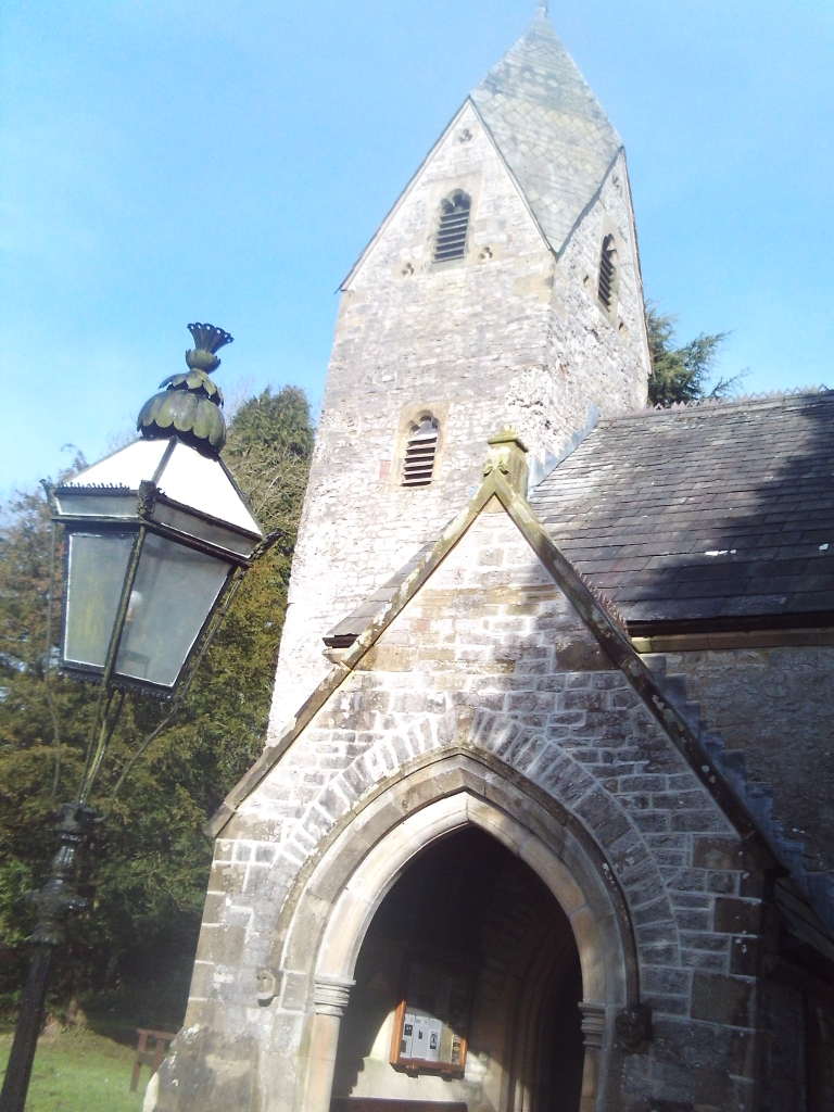
I travelled to Thorne on the train - it's only about ten miles to the north east. I got off and walked towards the town centre, where there were a few buildings for me to photograph.


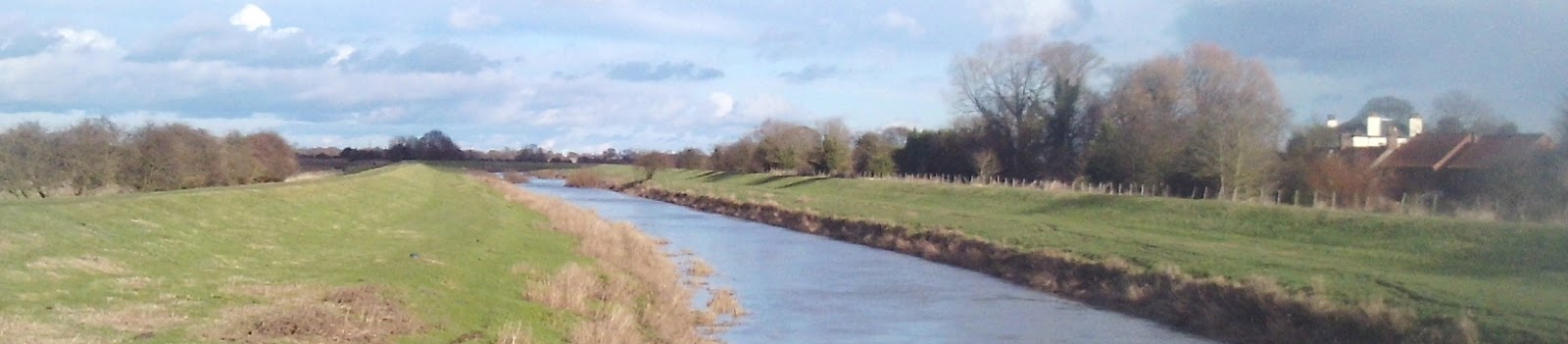
I then made my way towards the canal, passing by the entrance to Blue Water Marina on the way. Nearly fifteen years ago when I was on a workfare placement one of my assignments was to organise a marine radio operator's licence training course here.


I was heading pretty much due east as I walked along the towpath for the next four miles, passing over the boundary into Lincolnshire just before a location called Medge Hall. 


I crossed over the canal and the level crossing here and headed north east. As I walked along here I could see the buildings of Crowle over to my right.

After about a mile and a half I took a sharp turn to the left and started the return leg of the walk, soon entering Crowle Moors Nature Reserve...the path here was flooded, but was okay as I continued towards Thorne Moors and then to Moorends...where I had to walk through a housing estate until I reached the bus stop.


I've not included any photographs of the moors themselves because I didn't take any; they are rather featureless - just reed beds, areas of birch woodland, shallow lakes, and smaller areas of grassland...but absolutely flat. In the distance there are views of several wind farms, a couple of power stations, and Goole Docks. My camera's zoom lens isn't good enough to take shots of anything on the horizon, and even if I was interested in wildlife there wasn't any around at this time of year...nothing that I was aware anyhow; except birds...and I hate birds - I don't find them interesting at all - give me some well weathered rocks to look at and photograph any time though.


Friday, February 23, 2018

Monyash, High Peak Trail, Middleton-by-Youlgreave, Bradford, and Haddon Hall

I caught the local bus from Bakewell to Monyash and as soon as I arrived there I headed off down the road towards the High Peak Trail. It was then an easy and level three miles until I turned off and walked down Green Lane towards Middleton. I stopped at Parsley Hay along the Trail to eat my sandwiches inside the Istrian kožun, a circular stone shelter.


About half way along Green Lane I noticed a weathered stone tablet set into a section of wall.


It was difficult to make out the letters, never mind attempt a translation. At the time I thought that the first line mentioned something about the waters of the River Derwent...as it turns out, according to Google Translate the word that I assumed was the Latin name for the River Derwent actually means 'affront.'

For any linguists reading, the full inscription is:

AQVAE ARNEMETIAE DERVENTIO
HVIVS VIAE CVRAM CVRATORES
VIARVM NON SVSCEPERVNT'


I'm none the wiser after typing the words into Google Translate. Apart from 'affront' the other words and phrases that it suggests are 'water' 'of the way' 'they took care of roads' and 'curates'. I've tried re-arranging them and nothing really makes any sense.

I took a different footpath from Middleton to Bradford, only briefly dipping down into the valley, and then continuing on higher ground, bypassing Alport to the south.


The final stretch of the walk was across Haddon Fields and then down to the bus stop at Haddon Hall.

I'm still recovering from a cold today and so I'm pleased that I managed nine miles; I feel fine as well now that I'm back home.

UPDATE: I've done a bit of research online and found out that Green Lane runs along the course of a Roman road and the inscription laments the fact that neither the Romans, nor anyone else has bothered to maintain it. I still don't know what the exact translation is yet.

I've also been told that I've made a mistake with copying down some of the lettering...the correct word is the part of the Latin name for Buxton.

Tuesday, February 20, 2018

Using Public Transport On My Walks

I use public transport when I go walking and regularly write about my experiences; fortunately it's quite good in the Peak District and the other areas where I go for walks, the bus services are regular and generally quite reliable.

I don't need to worry about the trains; there are a lot that run between Doncaster and Sheffield - I rarely have to wait more than twenty minutes...and I can use my pass to travel for free on any train.

Buses are generally less frequent and so I need to know in advance what times they are running. All of the timetables are online and so I can print off copies, or just note down the details I need.

The information at the actual bus-stops in Derbyshire is very good, each stop has a unique combined timetable listing all the departures in chronological order. In South Yorkshire and Nottinghamshire only the individual route timetables are displayed.

As for the service frequencies; into the Peak District there are two buses an hour to Bakewell and Chatsworth House [except for Sundays in winter] - likewise, Sundays excluded, there's a half hourly service to Bradfield. An hourly service operates along the Hope Valley to Castleton and the X17 runs every hour to Matlock via Chesterfield. There are less frequent services to Buxton and Fairholmes in the Upper Derwent Valley; I usually only catch these buses for the outward journey since if I don't get back to the bus-stop in time for the trip back to Sheffield I will face a long wait...or a long walk. Additionally there are frequent commuter services out to the western suburbs of Sheffield; places such as Totley, Dore, or Lodge Moor aren't too far away from the Peak District. Further north, places in the Upper Don Valley can be easily reached as well. Annoyingly though, not all bus services in Sheffield use the bus station. The services to Lodge Moor and Bradfield depart from Arundel Gate. There's also an occasional train from Doncaster which stops at Dore and Totley station.

Recently I've also been travelling on bus services within the Peak District; the TransPeak along the Buxton to Matlock corridor and the local buses from Bakewell going to the surrounding villages.

Locally, most places in Doncaster, and quite a few places further afield, are easy enough to reach, having at least an hourly service, although some of these involve travelling on a rather circuitous route. This means that I can get to areas south of Worksop and Retford - there are some pretty villages in this part of the country...and of course there's also the Chesterfield Canal - voted as the prettiest canal in England by one well-known publication.

One gripe that I do have is that when I scan my pass on the buses the procedure varies depending on what type of machine is being used. Some require me to press it against the front of the scanner, and some place it on the top, either on a pane of glass or on a large green dot...then of course sometimes I'm issued with a ticket and sometimes I'm not...so I'm either standing there waiting for a ticket or I'm halfway down the bus when the driver calls me back to collect my ticket. Overall it's not that much much of a problem, and it's better than having to pay;it's not just the cost, but having to decide in advance what my destination is and what type of ticket I need to purchase. 

Monday, February 19, 2018

Blog Comments

Long time regular visitors to the blog will have noticed that for the last couple of years there have been very few comments posted; this is because I changed the settings. At that time the blog was being overwhelmed with spam comment and so I made it so that only people who were signed in to their Google or Blogger accounts would be able to post comments. The blog still receives comments but they are posted on the walking forums I'm a member of, or in response to me posting the link on various Facebook group pages...unfortunately these comments and replies don't appear on the blog.

Friday, February 16, 2018

Tideswell, Miller's Dale, Wormhill, and Blackwell

As the bus was travelling down the hill towards Grindleford the driver stopped the vehicle and told us that on his way in to Sheffield earlier this morning he'd seen a herd of deer in the woods over to the right, right up against the boundary wall. He then deliberately drove very slowly for a few minutes until we could see them - a stag and two hinds, a bit deeper inside the wood by now. This was a good start to my day; I've never seen deer here before - of course I've seen plenty in Chatsworth Park and on the Eastern Moors...and in other places away from the Peak District.

I travelled to Tideswell to start my walk, took some photographs of the church and then headed off to Miller's Dale down some narrow country lanes.


At Miller's Dale there's a path that goes up and behind the church and leads to the Wormhill road.


I was able to use a footpath for the last few hundred yards as I approached Wormhill; it comes out right at the back of the churchyard...a delightful spot to eat my sandwiches in the sunshine.


I then walked through the village and turned left to join the Pennine Bridleway, going through a farmyard.

I was interested to read this sign [a different farm.]


The village of Stilton is now in the county of Cambridgeshire, but only cheese made from cows grazing at specific farms in Derbyshire, Leicestershire and Nottinghamshire which meet strict criteria can legally claim to be 'Stilton Cheese.' No cheese is produced at Stilton, but if it ever were to be it couldn't legally be called 'Stilton Cheese.'

A few minutes later as I was carefully closing a farm gate behind me something at the bottom of the gate got caught up with the back of my left boot and instantly ripped off the sole. I had no means of re-attaching the sole and there wasn't much left at all to protect my foot...so I needed to put on both socks of the spare pair I always keep in my rucksack, a thick heavy pair of hiking socks. These provided quite a bit of padding, but I still needed to be very careful where I placed my left foot in case I trod on something painful as I hobbled to the nearest bus stop at Blackwell.

That's two pairs of boots and a rucksack that have fallen apart as I've been walking in the Peak District in the last six months...it's not a cheap hobby is hiking.


Wednesday, February 14, 2018

Upton, Badsworth, East Hardwick, Wentbridge, Kirk Smeaton, and Norton

I'm really struggling with the weather forecasts at the moment; using them to decide where and when to go for a walk. Today's forecast was for 'a bit of rain' in Bakewell in the Peak District this afternoon and 'occasional rain' for here in Doncaster. I'm not sure which would be worse though, a bit of rain or occasional rain. Whichever, I'm convinced that modern weather forecasts aren't as good or useful as they used to be in the 1970s, there's far too much superfluous information provided. Since the direction of any bad weather would be coming from the south west I assumed that it would reach the Peak District first...and so opted for a local walk. I stuck with this decision even when a few hours later the forecast had been updated to 'light showers.' As it turned out whatever phrase I preferred the forecast was very inaccurate, the rain arrived at least two hours early from a different direction, the southeast...and at times it was quite heavy with a bit of sleet.

I caught the Wakefield bus and got off at Upton and walked along the road that leads to Badsworth and then took the path that starts at the back of the water tower and goes across the fields, eventually to Badsworth.


The approach to Badsworth along a tarmac'd path which leads directly to the churchyard is lovely.


As I was walking along the bridleway heading towards East Hardwick I spotted something in a nearby field that I've not seen before - several hundred canes with something white attached to each one, neatly positioned in four or five straight lines, occupying only one specific area. I don't know what this is for.

The photograph isn't very good.


A few yards further on there was something else I hadn't seen before either - a gravestone for a road that's died.


The inscription reads, 'Here Ends Ackworth Bulls Road.'

This bridleway ended at the Doncaster road just south of East Hardwick, just before this lovely milestone: there five destinations to the north, the direction I was walking...but only Doncaster in the other direction behind me.


I ate my sandwiches in the churchyard at East Hardwick; the church is a rather plain and uninteresting Victorian building and so I didn't bother taking any photographs.

I took a muddy path across a field and then walked along a couple of different roads until I reached the footpath leading up onto Went Edge [or Went Hill.]


Although it's only about two hundred feet above sea level there are some good views from along here - it was very windy and exposed though today...especially since the rain, of whatever type, had started to fall.

As I crossed over the bridge at Wentbridge I stepped out into the middle of the road to take this photograph of the blue plaque giving details about Robin Hood.


There was a good view of the church in the distance as I entered Brockadale and followed the course of the River Went to Kirk Smeaton.


I'd had enough of the rain and the cold wind when I reached Kirk Smeaton and so I walked down the road to Norton, getting there as quickly as I could; I had about fifteen minutes to wait for the bus back to Doncaster.


Sunday, February 11, 2018

Thorne, Fishlake, Kirk Bramwith, and Stainforth

It's only seventeen minutes on the train from Doncaster to Thorne if it stops at all the intermediate stations, or only twelve minutes if it's one of the rare direct services. However, it takes me twenty minutes to walk to the railway station so overall it's not much quicker than catching one of the buses which comes up my end of town...but the first bus on a Sunday doesn't leave until after I'd already arrived in Thorne on the train.

There are two railway stations at Thorne, Thorne North and Thorne South, serving two different lines - yet neither of them being close to the town centre. The first two trains on a Sunday morning from Doncaster arrive at Thorne North on the Hull line...the other line goes to Cleethorpes. 

I didn't walk into the town centre; I just found [at the second attempt] the footpath I needed which goes through a housing estate and then becomes a rough track. I then reached an area of scrubland which was overgrown with thick brambles in places  and randomly placed rather sad looking scruffy long haired horses were chained to spikes that had been hammered into the ground. Where there weren't any horses there were heaps of hundreds of empty Foster's Lager cans...plus other empty cans and bottles as well.

The path took me over a pedestrians only crossing where there were half a dozen recently placed bouquets or floral displays; the flowers seemed quite fresh so I'm assuming someone might have died there recently...or more likely the anniversary of someone dying there had just passed.

I reached the service road for The Range Distribution Centre and then took the road that crosses over the motorway. According to the Ordnance Survey map, or at least what I could see on the sheet  there should have been a couple of paths passing under or over the motorway but I couldn't find either of them, and I doubt they even exist any more. Walking along this road added about a mile to the route; there was a greater variety of discarded lager cans thrown at the side of the road - there were still plenty of Foster's though.

I crossed over the River Don using a designated weak bridge which looked quite dilapidated.


I had a choice of routes to Fishlake but chose the signposted byway; it's a very pleasant route and there are plenty of rabbits - a couple of them scurried away just a couple of yards in front of me. My friend from Leeds phoned up to arrange our meeting  in the city next weekend as I was trying to stay out of the worst of the mud along here.

The church at Fishlake is left unlocked and so I went inside after I'd eaten my sandwiches.


The walk to the next village, Kirk Bramwith, took me along farm tracks, footpaths across fields, and along country roads. En route I came across what must be the  strangest roadside shrine I've ever seen, featuring a transparent plastic teacup and a shabby anorexic doll.


It was the second day of the snowdrops festival at Kirk Bramwith Church; I went inside and bought a cup of tea...the ladies had sold out of cake though.


The final couple of miles was a walk along the levee, with the River Don to my left and the Stainforth and Keadby Canal to my right.


The bus stop at Stainforth is right next to the church, which is a twentieth century building I think. I only had ten minutes to wait, long enough to take a quick photograph of the church tower though.