Showing posts with label The Great Ridge. Show all posts

Monday, October 4, 2021

Heatherdene, Hope, and Castleton

I travelled to Heatherdene this morning, on the bank of the Ladybower Reservoir. I started taking photographs as soon as I got off the bus and continued to do so until I reached the woodland on the other side of the dam wall.


The smell of the pines and the autumnal dampness was quite calming as I climbed up through the woodland and then used a path I'd not used before to get to Hope Cross, providing me with some different views of The Great Ridge.


I looped round to Edale End, went south for about a mile and then turned right heading for Losehill Farm and the way to Castleton. However, when I reached an area known as Townhead just to the north of Hope there's a footpath shown on the map, but there's also a chained up gate and no sign of the path. So I had to backtrack and go along the road for a few hundred yards, entering the fringes of Hope until I found the next path going across the fields to Castleton.


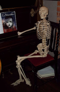
I had time to pop in to the Peak Hotel, billed as 'the Peak District's eccentric alehouse' and take a photo of one of the regulars.


Sunday, April 2, 2017

Tideswell, Sparrowpit, And Castleton.

The bus journey to Tideswell from Sheffield started off by me helping a young Chinese woman, most likely a student, work out where she wanted to get off the bus. She just kept repeating the words 'Monsal Trail' and showing the driver her mobile phone. In the end the driver, myself, and another driver who was walking by worked out that she was wanting to go to Miller's Dale, the only place where she could easily reach the trail from anywhere along the bus route. 

I arrived at Tideswell, and without looking at the map, headed out of the village in a westerly direction hoping to soon come to a footpath which would take me towards Peter Dale. Maybe this was a mistake because I needed to walk along a road for more than a mile until I reached the entrance to the dale. I don't like having to frequently stop to consult my map...it spoils the walk for me. This would become even more evident later on when I got lost by just heading off in the general direction I needed to be going and somehow straying from a footpath which looked to be quite straight, and straightforward,  on the map.

There were some expansive panoramic views of the White Peak countryside from this stretch of road though.


It's a pleasant, and quite easy walk up Peter Dale and then Hay Dale, although I left the latter half way up to continue following the Pennine Bridleway along a well maintained track, then a short stretch of road until I reached the next footpath. There was then another short stretch of road...and then my problems began. I consulted the map, was confident that I'd memorised the route for the next mile or so until I'd reach the main A623 road. The path appeared to go pretty much in a straight line, and that's what I did - I could see where I was going and so just headed off in that direction. In one instance there was a well-defined path...and then a few yards later an open gate which I walked through without checking the map...then, a few minutes later a dry stone wall and no way out of the field. I retraced my footsteps and soon found another gate which was closed, but I only needed to lift the latch...so I assumed this must be the route of the footpath. Wrong again; more walls, fences and locked gates which I had to negotiate until I reached the road. I've just been studying the map again and I still can't work out where I went wrong...a bit of signage along the way would have helped here...as it would a bit later on past Sparrowpit when I attempted to climb over an old dilapidated gate and it broke, leaving me with a prominent bruise on my inner thigh to add to my recent collection.

I always walk briskly when I'm walking along busy roads so it wasn't long until I reached Sparrowpit. Most of the village was up a hill where I didn't need to go...but I did pass by the pub - and it's got a very unusual name, The Wanted.


After struggling to find the path again and having to forge my own route across open country I eventually reached Rushup Edge. The walk along this ridge was the highlight of the day as I enjoyed the views of the Vale of Edale and The Great Ridge - with the sun being at the perfect angle for photography.


As I approached Mam Tor I was aware that time was tight if I wanted to catch the next bus from Castleton and so consciously increased my pace, even breaking into a jog when I reached a tarmacked surface. I arrived at the bus station with about five minutes to spare; I think I must have jogged for about a mile [yes, mainly gently downhill] but I didn't feel tired, out of breath, or even that sweaty...my health and fitness is still improving and I'm getting younger by the day. I've discovered the fountain of eternal youth...I just need to invent a time machine now and maybe I'll be able to go back and put things right in my life.

Saturday, March 5, 2016

From The Archives: Castleton

Castleton is one of the Peak District honeypot tourist villages: it's usually very busy, being easy to reach from Sheffield. It's well-known for its four showcase caverns, its hilltop castle, jewellery made from blue john [a locally mined semi-precious mineral, unique to the area], and for the opportunity to climb up Mam Tor and the walk along The Great Ridge.

I usually just use the village as a starting or finishing point of a walk and so will be wearing my hiking gear, meaning that there are several of the pubs, cafes, and shops  where I would feel rather uncomfortable.

My most memorable moment at Castleton happened last year when I was queueing at the counter at the fish and chips shop. I was standing next to a stunningly sexy, curvaceous young female cave diver who was wearing a skin tight, almost transparent, wet suit. When she asked if it was okay if she could put her flippers, snorkel, and goggles on the counter so that she could reach for her money I was a bit puzzled as to where she might keep it. Well...I took a sharp intake of breath as she unzipped her wet suit, exposing quite a bit of naked flesh as she reached inside and removed a couple of banknotes stuffed into a cellophane bag.


The photograph I've included was taken quite close to the fish and chip shop, just a bit further along the road.

Sunday, April 1, 2012

To The West Of Castleton.


Although the majority of today's walk was to the west of Castleton, I started off by leaving the village in an easterly direction, turning off the main road into the Market Place and then heading up the lane which eventually goes to Bradwell; taking a very circuitous route because the Hope Cement Works is in the way.


The Market Place is merely a name these days; no market is held here...it is a rather pretty spot though.

The lane out of the village climbed steadily; at one side I could see expansive views of the Hope Valley, and then higher up as the direction switched to be heading towards the south west, Hope Cement Works came into sight - not a pretty sight, but as I was having a brief rest at the roadside, a car stopped not too far away and a man got out and took several photographs and engaged his travelling companion in lively conversation.

I continued along this lane and then took the track which leads to the disused Hollandtwine Mine, where I stopped to read the information board explaining everything about how the site has been restored and the spoil heaps levelled so that the view of Mam Tor is now no longer blocked.

I continued westwards along this track for about a mile until reaching the massive excavated hole of Eldon Hill Quarry, which is currently not in use; stopping briefly to rummage for something in my rucksack and catching sight of about two dozen paragliders hanging in the air above Bradwell Edge. Also when walking along this section I noticed a father and his young son bending down to pick up loose rocks; I surmised they were looking for fossils.

Another short section of road followed and then a path leading downhill and then uphill to Ruhsup Edge Farm, where a bit of help with locating the actual path would have been appreciated.

I was soon walking along the main Chapel-en-le-Frith road, but soon turned off to climb up through access land to reach the footpath which goes along the top of Rushup Edge, and then turned eastwards to return to Castleton. The actual highest point of Rushup Edge, Lord's Seat isn't very impressive at all, but there's a tumulus only a few yards away which you can climb to the top of to enjoy marvellous views of Mam Tor, The Great Ridge and Edale.


At this point I could make out people walking to the summit of Mam Tor, a very popular activity on a lovely sunny day. A few minutes later, when I took the photograph several dozen people were on the steps, or on the summit.


At this point I decided to make my way down to Castleton as quickly as possible and hope to catch the next bus. I had considered walking up to the rim of Winnats Pass for some spectacular views; something I haven't done yet...but it will have to wait until another time.

The quickest route took me down the abandoned road and past the Odin Mine Crushing Circle.


I did arrive back in time for the bus; in fact I had time to pop into the shop and visit the toilets at the bus station.