Showing posts with label Doncaster Greenway. Show all posts

Sunday, January 31, 2021

Walking To My Nearest Trigpoint

I spent a few minutes resarching this online, and my nearest trigpoint turned out to be where I thought it would be, at Pickburn, about five miles from where I live. By the way, a trigpoint is a low, pyramidal concrete pillar used for surveying by the Ordnance Survey many decades ago. 

After walking through the town centre I used a stretch of the Doncaster Greenway. There are several railway themed benches installed at various locations along the network of trails; I photographed two of them today.


I reached Highfields Country Park and then Brodsworth Community Woodland. 


The location of the trigpoint as at the side of the road at the start of the bridleway that goes to Hooton Pagnell. I've been a bit suspicious that this has always been the location of the pillar though, it looks as if it's just been dropped there after possibly being moved from another location.


I continued beyond the trigpoint, dropped down into Brodsworth and then walked along the country road which would get me back to town as quickly as possible.


After a few hundred yards there was a footpath sign, this was the start of a path I'd not used before; that always adds a bit of extra interest to a walk. I walked through a wood at the back of the houses on Green Lane and then joined the cycleway which goes along the Roman Ridge to within less than two miles from the town centre.


UPDATE: Here's the map showing the location of the Stirling Single bench that Richard asked about in his comment.


Friday, July 17, 2020

Brodsworth Community Woodland

I walked to Brodsworth Community Woodland to photograph some of the outdoor sculptures there...I missed quite a few of them though, I couldn't remember exactly where they were.

I used the Doncaster Greenway to get to Highfields Country Park, which is just before the community woodland - most of the greenway goes along the route of a dismantled railway track. I returned to town using the cycle track and footpath that goes along the Roman Ridge.


[Maybe the flowers growing on this allotment are for the bees.]


I made my way straight to the summit of the woodland, it's quite prominent, but it's not the highest point in Doncaster by a long way.


From near the summit there are good views of Brodsworth Hall in the distance.


Overall I'm quite happy with the results using my recently bought £10 camera for the first time.

Wednesday, May 13, 2020

Doncaster Lakeside, Bessacarr, Old Rossington, Old Cantley, and Cantley

Today has been the first day since the start of the lockdown that we're able to  go for a walk without fear of being arrested by the police - that's a phrase I never thought I'd be writing on my walking blog in 2020 in England.

The weather's not been as nice as it has been recently but I still took advantage and went on a local walk, about ten miles, setting off from my doorstep - public transport is only running a very limited service and I would feel uncomfortable with the social distancing measures anyhow.

So...I left my house and walked through the estate to Doncaster Lakeside and then took the section of the Doncaster Greenway that goes just to the south of the houses at Bessacarr; I went there last week and visited the Stoven's Plantation area over to the right.


I saw several of these handwritten notices featuring random words - it must be some sort of improvised outdoor educational trail for children but it wasn't until I'd photographed the fourth sign, featuring 'train' that I was entirely convinced that they hadn't been put there by doggers last night.


There were some much more professionally produced signs a few hundred yards later after I'd turned right and headed along the path that crosses Doncaster Golf Course.


On the approach to Old Rossington I crossed over the River Torne and looked down into the water from the footbridge and saw some small fish, about two inches long - I don't know what they are.

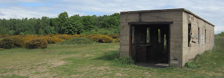
I walked along Littleworth Lane in the village before taking the path across the fields to the Mount Pleasant Hotel. After about half a mile I reached a lovely open area of heathland where I came across some wartime ruins, some of which look like they were gun emplacements - I don't know what the building with the railway tracks inside is though. 


This area was the highlight of the walk; sandy heathland with plenty of flowering gorse, the ruins to explore, and then further on a wildflower meadow - this was one of only two limited areas I'd not previously visited.

I then walked for about half a mile up the Great North Road and found the path that goes through woodland and then through Hayfield Lakes Angling Club to Warning Tongue Lane. I continued to Old Cantley and made my way through Cantley Park until I reached the houses at Cantley. I wasn't sure exactly where I was, but I worked out how to get down to the main road by studying the route and timetable at a bus stop.  I was on the Great North Road again, but further north,  and returned home by the shortest route.


Sunday, November 20, 2016

Doncaster, Bessacarr, and Loversall

I woke up quite late again this morning after a night out, in Doncaster this week; so a rainy start to the day wasn't going to be problem; I had time to have breakfast before the weather cleared up later in the morning and I set off for another local walk...starting from my front door again.

I walked down my street and took a short cut through the estate to the football ground and Doncaster Lakeside before joining the Doncaster Greenway until I reached Bessacarr.


At Bessacarr I found the correct bridleway, which immediately meant I had to use a manually operated level crossing across the Doncaster to Lincoln railway line; it's nothing complicated...just two gates to open and close.

A few hundred yards later the bridleway crosses over the East Coast Main Line, a multi-track, very busy high speed intercity line with overhead electrical wires, obviously presenting a few problems for people on horseback.

Anyhow...this is the solution; it's most likely the most costly-to-build footbridge I've ever used.


The next section of my walk went alongside the M18 motorway, which fortunately is well screened by trees, and then across a rather unattractive area of land near to where what I think is the new National College For High Speed Rail is being built.


The approach to Loversall was quite pleasant along a country lane, and Loversall itself is a pretty little village.


There were about a dozen young men mowing the grass and tending the graves in the churchyard. When the supervisor noticed me taking photographs he asked me if I wanted to look inside the church. He had the keys and so opened it up for me and gave me a brief talk about the building and its history - he was a local man.


As I left the village I crossed the road to check the bus timetable at the bus stop and then plan what I'd do next. A bus back into town was due in six minutes so I just stood where I was and waited for it. It actually arrived a couple of minutes early.