The drivers, or conductors, on Northern Trains were on strike today so there were fewer trains than usual going to Sheffield - so that's a good enough reason for me to have chosen a walk that means just travelling on buses.
I caught the service number 99 to Retford and then only had ten minutes to wait for the number 97 and the short journey to Clarborough.
I got off the bus and walked down Church Lane, arriving at the church a few minutes later.
The route of the footpath across the fields towards the Trent Valley Way was difficult for me to find, and I actually went the wrong way, going about a mile and a quarter further than I'd planned. The path was quite overgrown in places with nettles, thistles, and brambles and wasn't signposted at all; there were just difficult-to-see kissing gates along the way. I didn't really mind about the extra distance though because I ended up quite high up with some lovely views.
As I entered South Wheatley I immediately turned right and headed for the ruined church, where I ate my sandwiches sitting on a bench in the well-maintained churchyard.
There's a footpath which runs alongside the churchyard and according to the map heads straight for the still active church at North Wheatley at the top of the hill. I followed the path across a field but couldn't find any way out, even after a complete circuit...so I returned to the road and headed off in the direction of Sturton le Steeple. As I left South Wheatley I took a photograph of the village's welcome sign, as I always do when I'm entering or leaving a village in Nottinghamshire. I really like these signs, and have photographed quite a few now - the ones for each village are unique and feature something associated with the place, either historic or cultural. I added three more to my collection today.
I chose to take one of the footpaths across the fields to Sturton le Steeple; I wish I hadn't though because just after I'd crossed the railway line which leads to West Burton Power Station I found myself needing to walk through a field of impenetrable rapeseed. I chickened out and walked around the edge, which was still difficult enough - somehow I reached the road without too much trouble, although my clothes were covered in seeds, insects and pieces of whatever vegetation had stuck to me.
Despite the name of the village being 'Sturton le Steeple' the church actually has a tower, not a steeple...although it is quite unusual and has some features which are maybe more like a steeple.
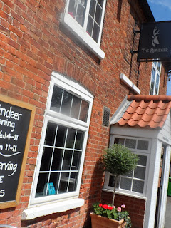
I popped in to The Reindeer pub across the road from the church and ordered a pint of Diet Pepsi; at only £1.20 it was the least I've paid for a very long time. Cheers!
I took the footpath across the fields to the next village, North Leverton with Habblesthorpe, which is the longest official place name in England, and the second longest in Europe...only beaten by Llanfairpwllgwyngyllgogerychwyrndrobwllllantysiliogogogoch in Wales.
It's only a short walk along the lane to North Leverton Windmill, which was turning as I passed and took some photographs.
I continued to head due west across a variety of landscapes until I reached one of the back streets of Welham and then a lane which led to the outskirts of Retford, from where I caught my bus back to Doncaster, from the Market Place.


No comments:
Post a Comment