Friday, February 9, 2018

Low Bradfield and High Bradfield Circular walk

I had three different, conflicting, and constantly changing weather forecasts to choose from last night and this morning when deciding where to go walking today: I decided though that it would be fine to make an early start for the Peak District.

I arrived at Sheffield and left the railway station, running up the hill as fast as I could towards Arundel Gate to catch my bus, weaving in and out of groups of people like a demented rugby player who'd forgotten to carry the ball. As I reached Arundel Gate and was waiting for the pedestrian crossing to turn to green I saw the number 61 pass bus going to Bradfield,  the bus that I was hoping to get. I gambled and ran over whilst the crossing was still showing red and desperately lunged for the try line...but the bus had already departed...sometimes it waits in for a few minutes, but not today.

So...a wait of thirty minutes at a bus stop on a busy road at the back of the Crucible Theatre: The next service was a few minutes late but the driver made up time to arrive at Low Bradfield on schedule.

I walked along the road towards Agden Reservoir and then took the concessionary footpath which goes alongside the southern bank. It was quite muddy in places but I preferred this to the road - and there were nice views in places when there were gaps in the trees.


I reached the western extremity of the reservoir and then started walking along the northern bank for a few minutes until I found a path going in a straight line up the steep hillside, right next to a forestry plantation - I don't really like straight lines in the countryside.

This path soon turned to the right, and then to the left, to bring me out onto open heathland and then the moors, and finally a road. 


I headed north east and then east along this road, encountering one of the many ancient, but well-maintained, mileposts that there are in the parish of Bradfield.


There were some lovely views as I continued along the road...and a brief section of bridleway.


I took a footpath heading off uphill to the right; again walking in a straight line next to a pine plantation, until I reached another country road. I crossed this road; the next footpath was across access land and a few hundred yards later I arrived at a choice of footpaths; one was definitive and depicted on the Ordnance Survey map and the other was another concessionary path. I've been at this location before, several years ago and couldn't remember there being two paths...so I decided to take the concessionary path hoping to see some different views. I wasn't disappointed; the views looking down at Agden Reservoir were nice...unfortunately I was looking into the sun and was partially blinded by the glare....I managed to get a photograph of some sheep though.


This path came down off the moors onto a farm track, which in turn took me to the road that leads down to High Bradfield. A few hundred yards along this road two cyclists passed me, both rather overweight middle-aged men, one of them wearing only socks on his feet...bright pink fluffy ones.

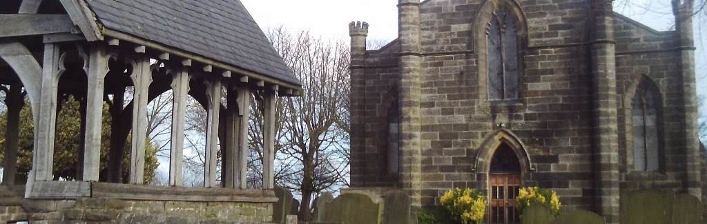
There's a church at High Bradfield for me to photograph.


I then walked down the steep road to Low Bradfield and caught  the bus back to Sheffield.

It's been lovely and sunny today; far better than any of the weather forecasts had predicted...ideal conditions for photography, but not necessarily for walking. There was a harsh bitterly cold wind blowing, which despite me wearing my thick woolly hat pulled down over my ears I still got quite  bad earache and so ended the walk early just before two o'clock...the fine weather looked as though it was set for the day though. As soon as I boarded the bus and got warm my earache cleared up and I'm perfectly okay now, sitting at home.


Monday, February 5, 2018

Clayworth, North Wheatley, Hayton, and Retford

Two consecutive days in the Peak District is a bit too much for me; it's not the walking, it's the getting there and back on public transport that's tiring. So...today I popped down to Nottinghamshire - the weather was forecast to be nicer anyhow. The bus to Retford goes from my local stop and only takes forty minutes, followed by a ten minute wait in the bus station, and then a short fifteen minute trip out to Clayworth. Total expected journey time...sixty five minutes.

Things didn't run to plan, but it wasn't a problem for me though. The number 99 was running about ten minutes late when it arrived at Retford meaning that I might have missed my connection; the number 97 Gainsborough service. However, since the same vehicle is used for both routes I merely got off the bus at the Retford Bus Station, went to the back of the queue and then re-boarded. All in all I arrived at Clayworth only about five minutes late.

I made my way through the village to the church and took some photographs before walking down Church Lane, heading east.


At the far end of the lane I picked up the footpath which led me across the fields to North Wheatley. A section of the route is part of the Trent Valley Way.

There were some good views of two power stations sited on the River Trent, West Burton, the nearer which wasn't generating any power today [I think it might be mothballed] and further away to the south is Cottam.


I entered North Wheatley from the west and walked through the village to reach the church. The church is actually a bit disappointing: it's nothing special to look at and is surrounded by trees and boxed in somewhat by modern buildings - so I found it difficult to find any interesting angles for photographs.


I headed off back in a westerly direction along farm tracks and fields until I reached Hayton. The church here was on the planned route I was taking anyhow.


I then continued down the lane to the canal and walked the final three miles along the towpath back to Retford.


Sunday, February 4, 2018

Ladybower Inn, Moscar, Hollow Meadows, Stannington, and Malin Bridge

I got off the bus at the Ladybower Inn, crossed the road and headed up the footpath onto the moors. I soon reached a section of path that had recently been repaired and a pull-out [and up] wooden tree identification board installed.


I tried to take a photograph with the panel extended...but I really needed an extra arm; whenever I pushed the shutter release button using one hand the camera moved so that I didn't get the image I wanted...not at all. 

The best views were behind me along here, looking back towards Win Hill.


The weather was still quite murky so there weren't a lot of good opportunities for photographs; this one I took of the old milepost turned out alright I suppose.


When I reached the ford near Cutthroat Bridge I stopped and had a brief chat with a student who was genuinely panning for gold; he had all the professional equipment by the look of things. I didn't want to disappoint him too much but did mention that I didn't know about any gold deposits anywhere in the Peak District. He seemed to be enjoying what he was doing though and so I left him to it - maybe it was a university project that he was working on.

I checked my map as I reached Moscar House, not just to check for directions but also to confirm that I was correct about a geographical curiosity in this area. There's nothing at all to see at Moscar, it's merely a collection of a small number of isolated farms up on the moors. The fact that makes it a bit interesting, for myself anyhow, is that there are several premises all of which feature 'Moscar' in their name...and they are located in three different local authority areas; High Peak Borough, Derbyshire Dales, and the City of Sheffield.

I continued walking eastwards towards Sheffield, quite often along the road, but sometimes taking a short section of footpath whenever I could...usually adding a few hundred yards to the distance.

Underbank Unitarian Chapel is just to the west of Stannington.


The Anglical church is about a mile further on in the main part of the settlement, which is a suburb of the city.


I'd already checked on Google Streetview where the footpath leading down to the Rivelin Valley was; it's a narrow snicket between two houses, which I could have easily missed.

The walk finished at the tram terminus at Malin Bridge and everything went according to plan all the way home on public transport.


Monday, January 29, 2018

Wadworth, Stainton, Maltby, Roche Abbey, Stone, Firbeck, and Oldcotes

Visiting four churches and an abbey today.

As forecast the rain stopped by late morning and by early afternoon the sun broke through the clouds to make a glorious second half of my walk.

I travelled on the bus to Wadworth, a journey lasting only fifteen minutes.


I  headed west and then south, walking along country roads and a bridleway until I reached Stainton. En route I passed by the back of Wilsic Hall School - I don't think their English department is very good though.


I didn't notice any spelling mistakes or grammatical errors at Stainton, although I wasn't looking for any.


At the side of the road leading south from the village there's a simple commemorative stone honouring the men who died in an accident at the nearby, now closed, Maltby Colliery. I continued along the estate road leading to Sandbeck Hall: the bridleway turns a sharp right at the main entrance though I did pass by Sandbeck Lodge later - by now the weather was bright enough for colour photography.


I left the estate road and took a footpath leading through some woodland which came out right at the edge of Maltby before heading off again away from the houses and down to the main Tickhill road, which I needed to cross before going down into the wooded Roche Abbey Valley; this name being a modern coinage I should think.

It wasn't long until I reached the substantial ruins of the abbey.


The approach to Stone, walking in an easterly direction  was lovely.


It was a bit muddy in places as I walked across the fields to Firbeck. The church here isn't very old but I think it's quite charming.


There was more mud as I walked down the lane, across more fields and then through the woods to reach the final stretch of road going towards Oldcotes. I had enough time here to photograph the small wooden church before I caught the bus back to Doncaster