Sunday, April 30, 2017

Fairholmes, Derwent Edge, Ashopton, Yorkshire Bridge, and Bamford

I travelled all the way to Fairholmes, on the train and then on the bus, with Douggie, a fellow walker from Doncaster. We've met quite a few times when catching the train to Sheffield but have never made any formal arrangements to meet up for a walk. Today he went walking over to Alport Castles...and I went in the other direction up to Derwent Edge, first reaching the Derwent Dam where I carefully photographed all of the new information panels.


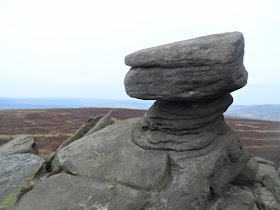
I immediately headed for open country, climbing up Hollin Clough and eventually reaching the toposcope at Lost Lad and then the paved footpath along the top of the edge, stopping to take photographs at Back Tor, the Cakes of Bread, the Salt Cellar, and the Wheel Stones.


It's a steep descent down to what remains of Ashopton village after the valley was flooded to make the reservoir. Something smelled very tasty as I passed the pub at Yorkshire Bridge; I didn't stop though because I wanted to catch the next bus back to Sheffield. I needn't have hurried though - I got the departure times muddled up; they are different on a Sunday...for several years though they hadn't been.

As I was standing at the front of the bus waiting to get off at the stop for the railway station in Sheffield Douggie came down the stairs from the upper saloon; He told me that he'd got on at Hope, a few miles before me. So we travelled together on the train to Doncaster - we didn't say much  to each other though...we both had a short nap.


Tuesday, April 25, 2017

Tideswell, Miller's Dale, Taddington, Monsal Head, and Ashford-in-the-Water

Today's walk was the route I'd planned to do on Sunday which I had to change because of the two hours delay on the train. Apart from the bus from Ashford-in-the-Water to Bakewell that was ten minutes there were no other problems on public transport.

I used the toilets at Tideswell and then took the most direct route out the village, up onto the fields and then along various lanes to reach Miller's Dale. 


After passing under the twin viaducts at Miller's Dale and walking along the road for a few minutes I found my next bridleway, which went uphill towards Taddington. I briefly chatted with a small group of cavers along this section who were checking and preparing their equipment; I looked and there is a cavern shown at this location on the map. I walked through Taddington and then took the footpath going down to the car park at Lees Bottom on the A6 trunk road.


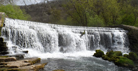
I crossed over the road; there's a bus stop here and so I just checked what time the bus arrives at Ashford, before continuing along the footpath at the side of the river until I reached Monsal Head. I managed to get my best photograph of the weir in Monsal Dale so far.


I climbed up to Monsal Head without stopping; I was a bit out of breath when I reached the top...but that's not too bad - I quickly recovered and continued on to Ashford-in-the-Water. By the time I got there the weather had turned quite nasty; a heavy hail shower and a cold, piercing wind; it had been mostly sunny with an occasional short, light shower of sleet or snow up until this point. The weather got even worse though as the Sheffield bus reached the highest point on its route at Owler Bar, we were caught up in a heavy snow shower...and the snow was starting to settle on the ground.

A mother and son couple [I think] who had got on at Baslow travelled all the way to Totley before realising that the bus wasn't going to Bakewell. and they obviously got off as soon as they were aware of their mistake. The son, who appeared to be charge, didn't seem to understand that they needed to cross the road in order to catch a bus back to Bakewell going in the other direction...he seemed rather distressed, and his mother confused. Yet another example of how having to scan free travel passes rather than state your destination is causing problems for some vulnerable elderly and disabled people.


Sunday, April 23, 2017

A Tragic Event Causes A Change Of Plan


Today's walk wasn't the one I'd originally planned to do; my arrival in Sheffield was over two hours late and so I just caught the first available bus to the Peak District, service 218, and got off at Clod Hall Crossroads and walked to Bakewell.

The delay was due to a suicide at Denaby. The train was held up at Conisbrough Station for about half an hour, we were then evacuated onto the platform and stuck there for another thirty minutes or so until we were told to get back on the train since it would now be returning to Doncaster where there would be taxis waiting to take us to Sheffield...there weren't any taxis booked when we got back to Doncaster though....but a coach did show up a few minutes later. So, a delay of well over two hours so I should receive at least two vouchers for a day's free travel on the Northern Rail network as compensation.

I got off the bus at Clod Hall Crossroads and noticed two young men walking in a direction I hadn't previously taken, so I followed them. As I'd hoped the path led to the top of Gardom's Edge, somewhere I haven't been walking before. I really enjoyed walking here; jumping from one flat topped boulder to the next and taking photographs of the rock formations and the views.


The footpath  I needed to take at Robin Hood isn't shown on the Ordnance Survey map and I couldn't find it, so I had to walk down the busy road to Baslow - there is a causeway though.

There are some nice buildings at Baslow....and a vintage car was in the car park at the Wheatsheaf Hotel.


I walked through Chatsworth Park to reach Edensor and then continued over Calton Pastures to Bakewell. I gave the bell a good whack at the golf course.


Fortunately my journey back to Doncaster was totally uneventful.


Saturday, April 22, 2017

Outdoor Sport Camping Paracord Parachute Cord Emergency Rope Survival Bracelet Kit Fire Starter Whistle Buckle Compass Wristband


I found one of these entangled in a tree as I was walking through a local wood with my support worker. I wasn't sure what it was; obviously I recognised that it was a wristband compass...but I didn't know about the other functions until I uploaded this photograph to Google Images. It's not a very good photograph...but it worked.

The whistle works and is quite loud, the blade is sharp, but not dangerous...I doubt I'll be using the other functions, but I'll read about them. 


Saturday, April 15, 2017

Totley, Lydgate, Horsleygate, Cordwell, Millthorpe, Moorhall, Oxton Rakes, Newgate, Barlow, and Unstone

Several new villages and hamlets visited today.

I travelled to the old brickworks on Baslow Road just past Totley and then walked back down to Gillfield Wood. I chose to take the high level footpath which goes to the picnic site, which seems to be a lovely spot with nice views, even though it's not very far from the road.

I then turned south and headed for Storth House; I soon came to a footpath diversion. I think I ended up walking nearly half a mile out of my way but the route was clearly marked and well maintained...and I did get to walk right through the large private garden of a expensive country house - and there were a lot of marsh marigolds to enjoy. 


The path actually came out at Fanshawe Gate, a few hundred yards further east. I picked up my intended route by walking down the road and then across the fields to Lydgate, just a collection of half a dozen farms and houses.

It was an easy, steady descent to Horsleygate, where the footpath goes right through the caravan park, right past the windows of some of the static caravans in fact. It was still quite early and I spotted one woman wearing only a skimpy nightie; she wasn't bothered...and neither was I.  

I couldn't locate the footpath to Millthorpe and so ended up at the next hamlet, Cordwell. I did mean that because I needed to walk along the road I did get to see a lot more of Millthorpe. I ate my sandwiches sitting on one of the seats next to the commemorative stone for a young pilot who died when his aircraft crashed nearby.


The next section of the walk was across fields and then up a byway through woods until I reached Moorhall. The map I was using to navigate was printed out last year when I first planned to do this walk; I'd circled a location in Hollin Wood as being something that might be interesting to look at. I can't remember what it was, and didn't see anything anyway.

The weather improved for a few minutes allowing me to take several photographs - here's the best one.


Oxton Rake is just a collection of expensive houses with large, well-maintained gardens - the route of the footpath here carefully wends its way around the properties...ensuring the privacy of the residents at all times.

Newgate was the final village of the day with 'gate' in its name; there's nothing to see there.

Barlow is a large village; the church is quite pretty although it has been extensively renovated since the eighteenth century.


This was the final horse I saw today; there are a lot along this route...I think I passed a couple of stud farms or equestrian centres.


By this time I was expecting an easy conclusion to the walk, just going through Cobnar Wood and the trading estate to reach the main road where I could catch a bus back to Sheffield. I got lost in the wood and then took the long way out of the trading estate; it being a Saturday there was no-one around to ask.


Sunday, April 9, 2017

Langold Lake Country Park, Firbeck, Roche Abbey, and Letwell

My first walk of the summer with my friends Chris and Maureen from Leeds. The original plan was for me to travel to Fox House and I'd be picked up and we'd travel to our destination in the Peak District but because of yesterday's railway strike I was worried that the early train from Doncaster to Sheffield might not be running. So, a change of plan: we met up at Warmsworth, just off the A1(M) roundabout and drove about a dozen miles to Langold.

What a lovely day for a walk, it was warm and sunny as soon as we stepped out of the car and the sun was still shining when we set off home...probably a bit too bright for photography, but I wasn't complaining.

It's a pleasant walk through the woods, across fields and down a bridleway to Firbeck, passing by an attractive lodge or cottage on the way.


We arrived at Firbeck more than half an hour before the pub was due to open and so ate our sandwiches at a picnic table outside the community centre. It was still only 11:50 when we'd finished them and rather than wait for the pub to open we decided to continue with the walk. Chris was keen to pop inside the Black Lion because he hoped that a particular piece of cricketing memorabilia might be displayed there. We discussed our options and decided to go to Roche Abbey and then return to Firbeck by a route that was slightly different in places....'there are toilets there' I commented to Maureen.

The route to Roche Abbey goes through Stone, a pretty limestone village. The first photograph was actually taken on our way back from Roche Abbey; it's my favourite though.


We got back to Firbeck and bought drinks in the pub. Chris was disappointed to find out that the earliest scoresheet on which the name of Fred Trueman, the famous Yorkshire and England fast bowler appeared, wasn't there. I found something amusing to take a picture of though.


I had the opportunity to see parts of the village that I hadn't seen before as we headed out in a westerly direction along a country road and across fields before looping back to Letwell.


Letwell has an interesting church and several pretty cottages.


We arrived back at Langold Lake at four o'clock; Chris wanted to walk round the lake but Maureen had had enough.